Seaside Home / Players, Coaches, Refs / Schedules & Results / Fields / Rules / FAQs / Lodging & Attractions / Vendors / Volunteers

Directions
|
Below are driving directions to the playing fields and local hospitals. Normal commuting times to Kingston and Charlestown, RI are 45-50 minutes from Providence, RI and 15-30 minutes respectively from Mystic, CT. However, on a nice weekend there can be considerable traffic going toward the beaches in the morning and from the beaches in the afternoon. We suggest that you allow for this traffic by leaving an extra 30 minutes for getting to the fields (more if you have the first game of the day). When returning to your hotel on nice days beach traffic can be very heavy on Route 1 from mid-afternoon until 6 or 7 p.m.
*If heading to the tournament from Coventry, Warwick, and/or Providence area you may want to consider taking the back roads (Rt. 2 and Ministerial Rd.) to avoid beach traffic on Rt. 4 and Rt. 1. |
|
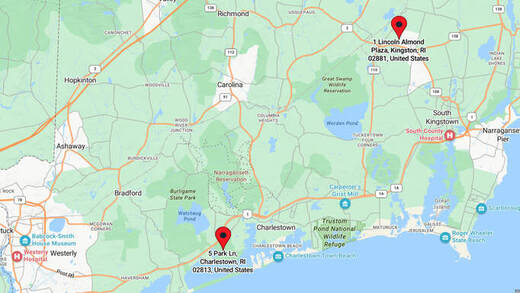
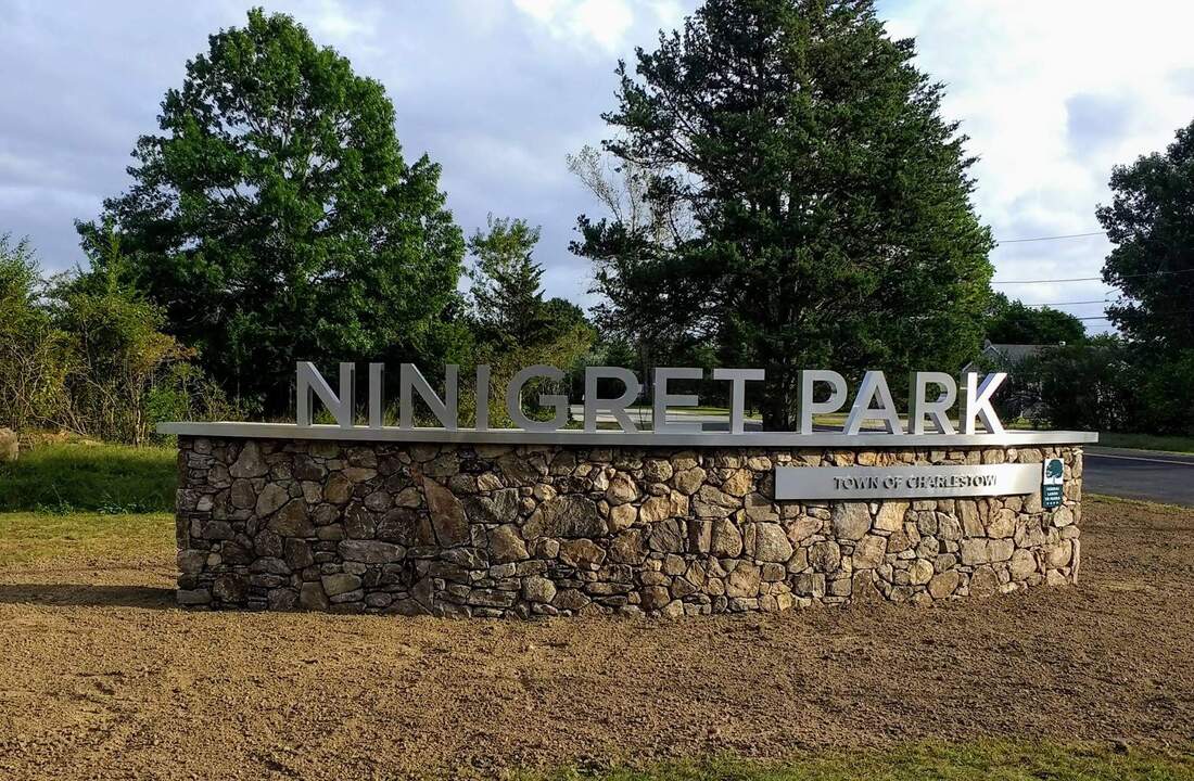
NINIGRET PARK FIELDS - 5 Park Lane, Charlestown, RI, 02813 (MapQuest)
From the Mystic, CT Area: Take Rt. I-95 north from the Mystic area and proceed about 10 miles to the Rt. 216 exit in Clarks Falls, CT. (we suggest you avoid taking CT Rt. 2 to RI Rt. 78 connector because of beach traffic). Take the exit and proceed south on Rt. 216 - the route will become RI Rt. 216. Follow Rt. 216 for 8.4 miles until it ends at Rt. 1. Take Rt. 1 north (a left) for about 2.8 miles and take the exit for Rt. 1A, Old Post Road, Ninigret Park. Go about 0.2 miles on Old Post Road and turn right on to Park Lane - the park entrance. Follow signs for parking. From the Providence / Warwick areas (north): Take I-95 south to the left-hand Exit 9 (Rt. 4 south). Stay on that road (it will turn into Rt. 1 south) for about 16.5 miles and watch for the Wakefield Business District exit. Continue past that exit for about 12.6 miles and look on the left for a sign for Ninigret Park, which will involve a left- hand exit and U-turn on to Rt. 1 north. Then almost immediately exit right on to Rt. 1A - Old Post Road. Go about 0.2 miles on Old Post Road and turn right on to Park Lane - the park entrance. Follow signs for parking. |
|
URI SOCCER FIELDS - 1 Lincoln Almond Plaza, Kingston, RI, 02881 (MapQuest)
(Parking along roads is not permitted - please see field map for designated parking areas) From the Mystic, CT Area: Proceed on Rt. I-95 North from the Mystic area. Take Exit 3A onto Rt. 138 East toward South Kingstown. Turn Left onto Plains Rd. Turn Right onto W. Alumni Ave. Park in Ryan Center Lot (lot should be on your left). Walk across the street towards the Ryan Center and soccer fields are located down Tootell Rd. Enter soccer fields from Tootell Rd. From the Providence/Warwick areas (north): Take I-95 South to the left-hand Exit 9 (Rt. 4-South). Take Exit 3B onto Rt. 102 toward Exeter. Turn left onto S County Trail. Turn left onto Kingstown Rd. Turn left onto Plains. Rd. Turn Right onto W. Alumni Ave. Park in Ryan Center Lot (lot should be on your left). Walk across the street towards the Ryan Center and soccer fields are located down Tootell Rd. Enter soccer fields from Tootell Rd. |
LOCAL HOSPITALS:
Make sure the player's medial release form is sent with any player going to the hospital. If going by ambulance, confirm to which hospital the player is being transported.
SOUTH COUNTY HOSPITAL - 100 Kenyon Avenue, Wakefield, RI (MapQuest)
From the Ninigret Park Fields: Turn left when exiting the Ninigret Park exit and proceed about one-third of a mile. Turn right to enter Rt. 1, north. Go about 11.1 miles and take the Salt Pond Road exit toward South County Hospital. At the end of the exit turn left on to Salt Pond Road. In 0.2 miles take a left on to Kenyon Avenue. Look for the Emergency/Express Care entrance about 0.1 miles ahead on the left.
WESTERLY HOSPITAL- 25 Wells Street, Westerly, RI (MapQuest)
From the Ninigret Park Fields: Turn left when exiting the Ninigret Park exit and then proceed about 1/3 of a mile. Merge right to enter Rt. 1, north; immediately get in left lane. Go about 0.2 miles and make a U-Turn on to Rt. 1, south ( If you miss it there will be another opportunity up the road a bit. Proceed 8.8 miles on Rt. 1, south and turn left on to Wells Street. The hospital is on your left about one-half of a mile up Wells Street.